| |
|
This
module compiled with information courtesy of the official NOAA Storm
Spotters Guide. |
| |
| SECTION FIVE: |
 As in the other sections,
you can click on the glossary image wherever you see it, and the glossary
will open in another window. Just close that window when you are ready
to continue.
 |
|
| THUNDERSTORM
COMPONENTS: |
| |
At
first glance, it may seem difficult to tell a severe thunderstorm
from a "garden variety" thunderstorm. There are, however, a number
of visual clues which can be used to gain an idea of a thunderstorms
potential strength and organization, and the environment in which
it is developing. Many of these visual clues are interrelated, but
for discussion's sake, we will classify these as upper-level, mid-level
and low-level features of the storm. |
|
| UPDRAFTS
AND DOWNDRAFTS : |
|
| All
thunderstorms require instability, moisture, and lift.
When moisture and instability are both present, it
is like mixing gasoline and air - the mixture has
explosive potential. The lift is like the spark that
ignites the mixture. Lift is produced by such things
as fronts and low pressure troughs, or by air rising
upslope. We say that the atmosphere is unstable when
air rising in a cloud is warmer than its environment,
like a hot-air balloon. It is the moisture condensed
within a cloud that permits the rising air to stay
warmer than its surroundings, and thus to be buoyant
through great depths. In the same way, air that is
cooler than its environment tends to sink as long
as it can stay cooler than its surroundings. The atmosphere
can be unstable for updrafts but stable for downdrafts,
stable for updrafts but unstable for downdrafts, stable
for both, or unstable for both. |
|
The
degree of atmospheric instability is one of the two major
factors in determining the strengths of thunderstorm updrafts
and downdrafts. Furthermore, vertical draft strengths basically
determine the degree of storm severity. If we consider a
"generic" storm, there are four possible combinations of
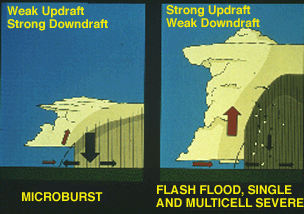
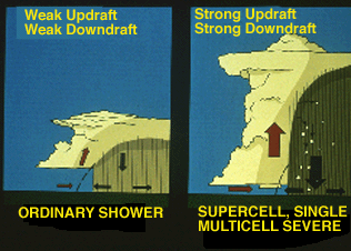
weak and strong draft strengths. When the low level air
is unstable but relatively dry and adequate mid-level moisture
is present, a storm may develop with a weak updraft but
a strong downdraft with the latter the result of strong
negative buoyancy and cooling through evaporation of precipitation
into the dry air. This high-based storm resembles high terrain,
western U.S. storms which occasionally produce dry microbursts.
Significant hail and rain are unlikely.
A
storm which contains a strong updraft and weak downdraft;
will not produce wind damage, but can foster heavy rains
and/or damaging hail. Single and multicell storms comprise
this category. They include storms that dump heavy rain,
but little or no hail because of warm conditions aloft,
and multicell storms that are capable of producing hail
because of lower environmental freezing levels. Strong updraft,
weak downdraft storms often form in very moist atmospheres
where there is little, if any, dry air and evaporational
cooling to drive downdrafts. |
|
Relatively
weak updrafts and downdrafts are found with non-severe showers
and thunderstorms. The last possible combination is a storm
with strong updrafts and downdrafts. These storms frequently
produce destructive downbursts, hail, heavy rain, and tornadoes.
As one would expect, the most severe storms, including supercells,
have strong vertical drafts and occur in the most unstable
atmospheres. |
|
|
| |
|
| UPPER LEVEL
FEATURES: |
| Most
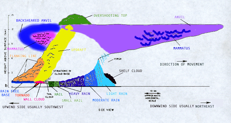
of the upper-level clues are associated with the storm's anvil.
Recall that the anvil is a flat cloud formation at the top of the
storm. Air and cloud material rising in the updraft reaches a point
where it begins to slow down. This level is called the equilibrium
level. The air and cloud material rapidly slows its upward motion
after passing the equilibrium level. As the air and cloud material
spreads out, the anvil is formed.
If the
storm you are watching has a vigorous updraft, a small portion of
the updraft air will rise higher than the surrounding anvil. This
will form a "bubble" of cloud sticking up above the rest of the
anvil. This bubble is known as an overshooting top. Most thunderstorms
will have small, short lived, overshooting tops. However, if you
observe a storm with a large, dome-like overshooting top that lasts
for a fairly long time( more than 10 minutes), chances are that
the storm's updraft is strong enough and persistent enough to produce
severe weather.
The anvil
itself provides clues to the storm's strength and persistence. If
the anvil is thick, smooth edged, and cumuliform (puffy, like the
updraft tower), then the storm probably has a strong updraft and
is a good candidate for severe weather.
If the
anvil is thin, fuzzy, and glaciated (wispy, similar to cirrus clouds),
then the updraft is probably not as strong, and the storm is less
likely to produce severe weather.
If the
anvil is large and seems to be streaming away from the storm in
one particular direction, then there are probably strong upper level
winds in the storms environment. The storm will be well ventilated,
meaning precipitation will be blown downstream away from the updraft
rather than fall through it. |
|
| MID LEVEL
FEATURES: |
| |
Most
of the mid level features are associated with the storms main updraft
tower. If the clouds in the main updraft area are sharply outlined
with a distinct cauliflower appearance, then the clouds are probably
associated with a strong updraft which may produce severe weather.
|
| |
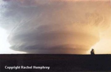
| If
they have a fuzzy, "mushy" appearance to them, then the updraft
probably is not as strong. If the updraft tower itself is vertical,
then the storm probably has an updraft strong enough to resist the
upper level winds blowing against it. On the other hand, if the
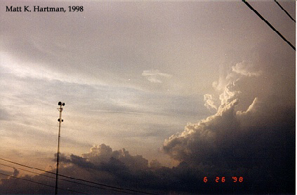
updraft leans downwind, the the updraft is weaker. The glaciated
anvil (in the above pic) and soft updraft tower suggest a lack of
severity. |
| |
| Thunderstorms
with good storm-scale organization typically have a series of smaller
cloud towers to the south or southwest of the main storm tower.
These smaller towers are called a flanking line and usually have
a stair-step like appearance as they build toward the main storm
tower. The above shows the flanking line from behind the storm. |
| |
| Some
supercells, as their mesocyclones develop, will show signs of rotation
in the updraft tower. You may see striations on the sides of the
storm tower. Striations are streaks of cloud material which give
the storm tower a "corkscrew" or "barber pole" appearance and strongly
suggest rotation. A mid level cloud band may also be apparent. The
mid level cloud band is a ring of cloud material encircling the
tower like a ring around a planet. This is another sign of possible
rotation within the storm. As you can see, the visual results can
be quite dramatic!
As a storm increases
in size and intensity, it will begin to dominate its local environment.
If cumulus clouds and other storms 5-15 miles away from the storm
of interest dissipate, it may be a sign that the storm of interest
is taking control in the local area. Sinking motion on the edges
of the storm my be suppressing any nearby storms. All of the instability
and energy available locally may be focused into the storm of interest
which could result in its continued development. |
| |
|
| LOW LEVEL
FEATURES : |
| Some
of the critical cloud features for assessing thunderstorm severity
and tornado potential are found at or below the level of the cloud
base. While there is a lot of information to be discerned in these
low level cloud features, most of the confusion and frustration
associated with storm spotting/chasing stems from attempting to
interpret these similar appearing but meteorologically distinct
cloud formation. |
| |
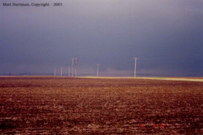
| Perhaps
the easiest low level feature to identify is the rain-free base.
As its name suggests, this is an area of smooth, flat cloud base
beneath the main storm tower from which little or no precipitation
is falling. The rain-free base is usually just to the rear (generally
south or southwest) of the precipitation area. The rain-free base
marks the main inflow area where warm, moist air at low levels enters
the storm. Some have called the rain-free base the "intake area"
of the storm. The below image shows that it may sometimes be difficult
to get good contrast on viewing the rain-free base.
We earlier
discussed the domination by a storm of its local environment. Besides
suppression of any nearby storms or clouds, this local domination
can also show itself through the presence of inflow bands, ragged
bands of low cumulus clouds which extend from the main storm tower
to the southeast or south. The presence of the inflow bands suggests
that the storm is gathering low-level air from several miles away.
The inflow bands may also have a spiraled nature to them, suggesting
the presence of a mesocyclone. |
| |
| The
beaver's tail is another significant type of cloud band The beavers
tail is a smooth, flat cloud band that extends from the eastern
edge of the rain free base to the east or northeast. It usually
skirts around the southern edge of the precipitation area. The beavers
tail is usually seen with high precipitation supercells and suggests
that rotation exists within the storm.
Lowerings
of the rain free base and "accessory clouds", such as shelf clouds
and roll clouds, mark important areas of the storm. |
|
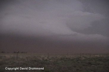
| As
you can see in this image, low level features are completely obscured
by dust picked up by inflow into the storm. This storm was possibly
tornadic for several hours, producing only one confirmed tornado
northwest of Cannon A.F.B. in New Mexico on June 4th, 2003 |
| |
|
|
|
| WALL CLOUDS
AND OTHER LOWERINGS : |
| |
| The
wall cloud is defined as an isolated cloud lowering attached to
the rain-free base. The wall cloud is usually to the rear (generally
south or southwest) of the visible precipitation area. Sometimes,
though, the wall cloud may be to the east or southeast of the precipitation
area. This is usually the case with high precipitation supercells
where the precipitation has wrapped around the western edge of the
updraft. Wall clouds are usually about two miles in diameter and
mark the area of strongest updraft in the storm. |
|
As
the storm intensifies, the updraft draws in the low level
air from several miles around. Some low level air is pulled
into the updraft from the rain area. This rain-cooled air
is very humid; the moisture in the rain-cooled air quickly
condenses to form the wall cloud.
|
|
| 
|
About
5 minutes after the above picture, the wall cloud/updraft
area began lifting dust the cloud base. This was the beginning
of tornadic cycle of the storm that lasted several hours.
Shortly after this picture the dust did a brief tornadic
circulation before dissipating and reforming later. |
| |
This
storm exhibits several good features that are visual clues
to the spotter/chaser. In the mid-levels we can see the
"barber pole" striations indicating visually that
this storm is rotating. More importantly is the development
of the massive wall and tail cloud underneath. Note that
this particular wall cloud does NOT slope, but your clue
here is the tail cloud forming back into the rain area.
This storm later produced an F1 tornado near Guthrie, OK
on June 13, 1998. |
| |
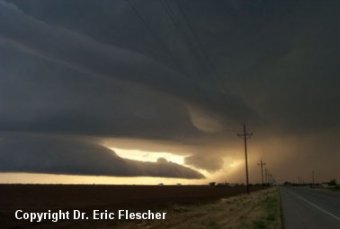
Another
dramatic image taken just outside of Lubbock, TX in June
2002. This is a good example of excellent contrast. This
huge wall cloud was very visible to the storm chaser that
took the image, and if a tornado were forming, it would
have been very easy to see. This storm however did not produce
a tornado, but did cause some extensive damage from rear
flank downdraft winds. |
| |
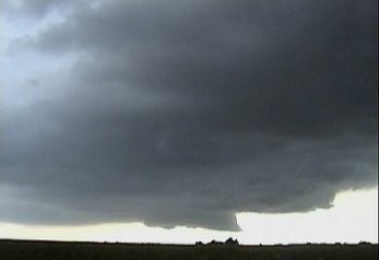
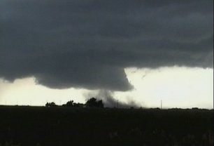
Sometimes
being in closer it is a little more difficult to distinguish
what you are seeing. This is a large wallcloud with developing
funnel. This produced a brief tornado near Anthony, KS in
May 1997 shortly after this was taken. Notice that while
we did have some good side lighting and could see what was
going on, it is very dark behind the funnel cloud, and not
as good of viewing contrast for spotting. |
|
| |
|
| SHELF CLOUDS
AND ROLL CLOUDS: |
|
Shelf clouds and roll clouds
are examples of "accessory clouds" that you may see beneath
the cloud base of a storm. Shelf clouds are long, wedge-shaped
clouds associated with the gust front. Roll clouds are tube
shaped clouds and are found also near the gust front. |
|
Shelf/roll
clouds can develop anywhere an area of outflow is present.
Shelf clouds typically form near the leading edge of the
storm or squall line. A shelf cloud can form under the rain
free base however, and take on the appearance of a wall
cloud. A shelf cloud may also appear to the southwest of
a wall cloud in association with a phenomena called the
rear flank downdraft (RFD). |
|
|
|
|
|
| SHELF
CLOUDS VS. WALL CLOUDS: |
| Perhaps
your biggest challenge as a spotter will be to discern between shelf
clouds under the rain free base and legitimate wall clouds. Remember
that shelf clouds signify an area of downdraft and outflow while
wall clouds indicate an area of updraft an inflow. If a shelf cloud
is observed for several minutes, it will tend to move away from
the precipitation area. A wall cloud, though will tend to maintain
its relative position with respect to the precipitation area. Shelf
clouds tend to slope downward away from the precipitation while
wall clouds tend to slope upward away from the precipitation area.
Only
a few of the lowerings that will be seen when spotting/chasing wall
be legitimate wall clouds, and only a few of these will actually
produce tornadoes. Once a wall cloud has been positively identified,
the next challenge will be to determine its tornado potential. There
area four main characteristics usually observed with a tornadic
wall cloud. First, the wall cloud will be persistent. It may change
its shape, but it will be there for 10-20 minutes before the tornado
appears. Second, the wall cloud will exhibit PERSISTENT rotation.
Sometimes the rotation will be very visible and violent before the
tornado develops. Third, strong surface winds will blow in toward
the wall cloud from the east or southeast (inflow). Usually surface
winds of 25-35 mph are observed near tornadic wall clouds. Fourth,
the wall cloud will exhibit evidence of rapid vertical motion. Small
cloud elements in or near the wall cloud will have these characteristics
(and some tornadoes do not form from wall clouds), but these four
characteristics are good rules of thumb to follow. |
| |
| |
| NON-TORNADIC
SEVERE WEATHER PHENOMENA: |
|
DOWNBURSTS
Recall
that a downburst is defined as strong downdraft with an
outrush of damaging winds on or near the ground. Downbursts
are subdivided based on their size. If the swath of damaging
winds is 2.5 miles or greater in diameter, then it is termed
a macroburst. If the swath is less than 2.5 miles, it is
called a microburst. In general, microbursts are quick hitting
events and are extremely dangerous to aviation. Microbursts
are sub-classified as dry or wet microbursts, depending
on how much or little rain accompanies the microburst when
it reaches the ground. |
 |
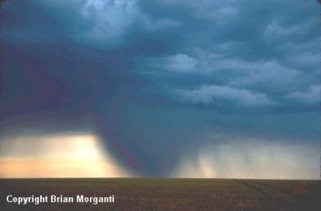
Here
we see the life cycle of a microburst. The formative stage
of a microburst occurs as the downdraft begins its descent
from the cloud base in the first picture. The microburst
accelerates downward, reaching the ground a short time later.
The highest wind speeds can be expected shortly after the
microburst impacts the ground, in the second picture. As
the cold air of the microburst moves away from the center
of the impact point, a "curl" will develop. Winds in this
curl will accelerate even more, resulting in even greater
danger to aircraft in the area. After several minutes, the
microburst dissipates, but other microbursts may follow
a short while later. |
| While
spotting microbursts may not seem as dramatic as spotting
tornadoes, it is important to the NWS, the public, and the
aviation interests that these microbursts be identified
and reported.
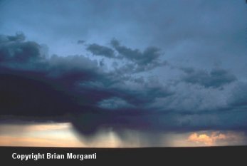
Some
of the clues that a microburst may be forming are:
- Patches
of virga mark potential microburst areas. As the precipitation
evaporates, it cools the air and starts a downdraft.
If the conditions are right, the downdraft may accelerate
and reach the ground as a microburst. Localized areas
or rings of blowing dust raised from the ground usually
mark the impact point of dry microburst.
- A small,
intense, globular rain area, with an area of lighter
rain in its wake, may mark a wet microburst. A rain
foot, a marked outward distortion of the edge of the
precipitation area, is usually a visual indicator of
a possible wet microburst. As the microburst reaches
the ground and moves away from its impact point, a plume
of dust may be raised from the ground. This plume is
called a dust foot and also marks a possible microburst.
|
|
| |
|
| FLASH FLOODS:
|
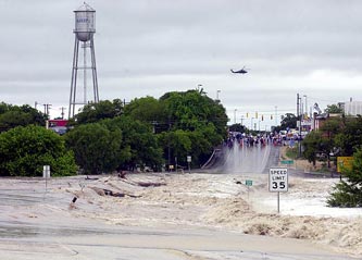
| For
many years, flash floods were the leading cause of death and injury
among weather phenomena. Although the death rates are decreasing,
people still fall victims to flash floods.
The atmospheric
conditions which cause flash floods have been somewhat different
from those with severe thunderstorms. The typical flash flood environment
has abundant moisture through a great depth of the atmosphere. Low
values of vertical wind shear are usually present. Flash flooding
commonly occurs at night, rather than in the late afternoon or evening.
Flash flooding is typically produced by either large, slow moving
storms or by "train effect" storms. The "train effect" occurs when
several storms sequentially mature and drop their rainfall over
the same area. This can occur when multicell cluster of squall line
storms are present. |
|
| |
|
|
| |
|


