 |
 |
This
module compiled with information courtesy of the official NOAA Storm
Spotters Guide. |
| SECTION TWO: |
| |
In this section, you will concentrate on identifying the features of storm structure. This is very important to know what the storm is doing, which way it is going, and keeping yourself in a safe position. The best viewing position if ideally to the right of the storm. Most commonly, many of the storms will move from SW to NE. Thus the best viewing position would be southeast of the storm. This would change somewhat in HP cells, but that will be covered in the Advanced module. Keep in mind, storms have no sense of direction, and do not know which way is north. They can move in any direction, and with the proper knowledge of storm structure and the movement of the storm, you can put yourself in the best viewing position. For our purposes here, we will assume that the storms are moving SW to NE. |
 |
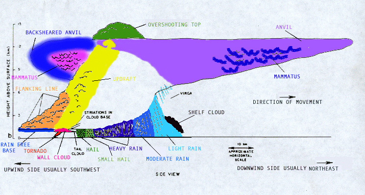 |
| In
the two images above, we see a side view drawing of a supercell.
The direction of movement in both is from left to right. Note that
the anvil is blown downstream in the direction of the movement of
the storm. This is a key way to identify the general direction of
the storm visually. The varies elements of the storm are identified
and color coded in the second drawing to make identification easier.
Make yourself very familiar with these terms and their location. |
| Below
we see a photo of a supercell storm. Since it is difficult to get
the entire storm in one photo, we will have to take a look at different
elements of the storm structure in different photos. |
 |
| In the above picture, we are looking SE at the storm. Movement is from right to left, SW to NE. We are to the NW of the storm. The various elements outlined are color coded as follows:
|
| |
 |
| In this photo from a distance, we can see some of the larger storm features. This storm is moving which way? You got it, right to left. Remember the direction the anvil is being swept is the general direction of movement of the storm. Features are anvil, the overshooting top, the backsheared anvil, the main updraft region, and in the boxes in the lower part of the storm, we would expect to see the rain-free base, the area of wall cloud/tornado development, the areas of large and smaller hail, and the areas of heavy, moderate and light rain. |
|
Image was submitted by a viewer of this site. |
| In
the above picture, we can see the Mammatus clouds, which appear
as lumps on the underside of the anvil of an departing storm. This
was taken in San Angelo, Tx. This storm was moving left to right
here, with the updraft to the right of this picture. |
