| |
|
This
module compiled with information courtesy of the official NOAA Storm
Spotters Guide. |
| |
SECTION
ONE: |
Contents:
 You will be able to access the Glossary in places where selected
terms are highlighted in yellow. Just click on the image where you
see it and the glossary will open in a new window. Just close it
when you want to continue.
You will be able to access the Glossary in places where selected
terms are highlighted in yellow. Just click on the image where you
see it and the glossary will open in a new window. Just close it
when you want to continue.
|
|
| Introduction:
The
following is an illustrated guide to what types of features are
often seen before and during severe weather events. Since supercell
thunderstorms produce the majority of severe weather and are common
in many parts of the country, this page focuses on this phenomenon.
Caution: Storm spotting is an activity performed only by trained
individuals! This page is not meant to be a substitute for official
storm spotter training.
Contact
your local NWS office for details on spotter training in your area.
The NWS does not sponsor storm spotters or storm chasers, but works
with them to obtain and provide up to the minute information on
severe weather. |
|
| Supercells: |
| |
| Thunderstorms
are common in many parts of the U.S., and most area residents are
quite familiar with them and the severe weather they can bring.
Most individual thunderstorms only last several minutes, however
some individual thunderstorms can last several hours. These long-lived
thunderstorms are called supercell thunderstorms. Supercell thunderstorms
are solely responsible for producing the majority of severe weather,
such as large hail and tornadoes, however, strong squall lines can
also produce widespread severe weather, primarily very strong winds
and/or microbursts.
A supercell
thunderstorm, in brief, is a thunderstorm with a persistent rotating
updraft. This rotation maintains the energy release of the thunderstorm
over a much longer time than typical, pulse-type thunderstorms which
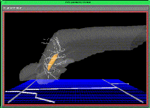
occur in the summer months in the U.S. A 3-D visualization of a
simulated supercell thunderstorm is shown below. Notice the rotating
streamlines around the orange, carrot-shaped object which indicates
the location of the rotating updraft. |
| |
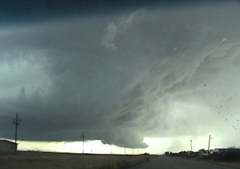
| A
diagram of a "classic" supercell is shown below. |
| |
| Notice
the wall cloud indicated above, which is often associated with supercell
thunderstorms, and can possibly lead to the formation of a tornado.
|
|
The
following section lists terms and definitions associated with supercell
thunderstorms: |
| |
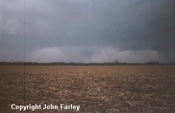
| Rain-free
base - A dark,
horizontal cloud base with no visible precipitation beneath it.
It typically marks the location of the thunderstorm updraft. Tornadoes
may develop from wall clouds attached
to the rain-free base, or from the rain-free base itself - especially
when the rain-free base is on the south or southwest side of the
main precipitation area. Note that the rain-free base may not actually
be rain free; hail or large rain drops may be falling. For this
reason, updraft base is more accurate.
|
|
| |
| Wall
cloud - A wall
cloud, according to the storm spotters glossary, is a local, often
abrupt lowering from a rain-free base. Wall clouds can range from
a fraction of a mile up to nearly five miles in diameter, and normally
are found on the south or southwest (inflow)
side of the thunderstorm. When seen from within several miles, many
wall clouds exhibit rapid upward motion and cyclonic
rotation. Rotating wall clouds usually develop before strong
or violent tornadoes, by anywhere from a few minutes up to nearly
an hour. Wall clouds should be monitored visually for signs of persistent,
sustained rotation. |
|
| |
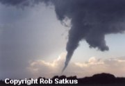
Tornado
- A violently rotating column of air in contact with the ground.
A condensation funnel does not need
to reach to the ground for a tornado to be present; a debris
cloud beneath a thunderstorm is all that is needed to confirm
the presence of a tornado, even in the total absence of a condensation
funnel. A description of tornado intensity classification is shown
below.
LP
storm (or LP supercell) - Low-Precipitation storm (or Low-Precipitation
supercell). A supercell thunderstorm characterized by a relative
lack of visible precipitation. Visually similar to a classic supercell,
except without the heavy precipitation core. LP storms often exhibit
a striking visual appearance; the main tower often is bell-shaped,
with a corkscrew appearance suggesting rotation. They are capable
of producing tornadoes and very large hail. Radar identification
often is difficult, so visual reports are very important. LP storms
almost always occur on or near the dry line,
and therefore are sometimes referred to as dry line storms. |
|
| |
| HP
storm or HP supercell - High-Precipitation storm (or High-Precipitation
supercell). A supercell thunderstorm in which heavy precipitation
(often including hail) falls on the trailing side of the mesocyclone.
Precipitation often totally envelops the region of rotation, making
visual identification of any embedded tornadoes very difficult and
very dangerous. Unlike most classic supercells, the region of rotation
in many HP storms develops in the front-flank
region of the storm (i.e. usually in the eastern portion). HP storms
often produce extreme and prolonged downburst
events, serious flash flooding, and very large damaging hail
events. Mobile storm spotters are strongly advised to maintain a
safe distance from any storm that has been identified as an HP storm;
close observations (e.g., core punching)
can be extremely dangerous. |
|
|
| Tornado
Intensity:
Tornadoes
vary in size and destructive potential. The winds of a tornado have
only recently been estimated with specialized radars (FM-CW), however
up until then, the Fujita Scale and the subsequent Enhanced Fujita Scale (EF Scale) has been used to quantify tornadic winds according to the extent
of damage to buildings and structures. |
Photos courtesy
of Rob Satkus, George Kuikendall, and NSSL, respectively |
| A
weak, strong, and violent tornado, left to right. It should be emphasized
that you can't always tell a tornado's strength by looking at it.
Sometimes a weak tornado may be doing EF4 damage, and a large tornado
may only do EF2 damage. The EF rating is officially given only after
careful analysis of the damage path by trained people. Spotters/chasers
should refrain from calling a tornado by an EF rating when reporting
it. |
|
|
ENHANCED FUJITA
(EF-SCALE) DAMAGE SCALE OR TORNADO INTENSITY |
| *NOTE: The traditional F-Scale has been revised and is now known as the EF-Scale or Enhanced Fujita Scale. |
| F
SCALE WINDS |
TYPE
OF DAMAGE |
RELATIVE
FREQUENCY |
| EF0 (weak) |
65-85 mph light
damage |
29% of all tornadoes |
| EF1 (weak) |
86-110 mph moderate
damage |
40% of all tornadoes |
| EF2 (strong) |
111-135 mph considerable
damage |
24% of all tornadoes |
| EF3 (strong) |
136-165 mph severe
damage |
6% of all tornadoes |
| EF4 (violent) |
166-200 mph devastating
damage |
2% of all tornadoes |
| EF5 (violent) |
Over 200 mph (rare)
incredible damage |
less than 1% of
all tornadoes |
|
|
| Notice
the relative frequency of each category tornado, less than 3% of
all tornadoes become violent, with winds that can level brick homes.
The image below shows what a violent tornado can do to a car, dramatically
illustrating why so many who remain in their vehicles when a tornado
approaches ... lose their lives. |

Photo
courtesy of the Pecos News.
|
|
The
following section lists other hazards and their definitions associated
with thunderstorms: |
| |
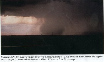
| Downburst
- A strong downdraft resulting in an
outward burst of damaging winds on or near the ground. Downburst
winds can produce damage similar to a strong tornado. Although usually
associated with thunderstorms, downbursts can occur with showers
too weak to produce thunder. |
Photo
courtesy of NOAA
|
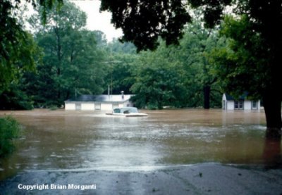
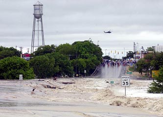
| Flash
Floods - Heavy thunderstorms which move very slowly or thunderstorms
which move quickly but redevelop over the same area can produce
flash flooding. If you are storm spotting and encounter water running
over a roadway, report it immediately. DO NOT TRY AND DRIVE THROUGH
THE WATER! Roadways underneath may not always be intact. |
| |
|
|
|
| |