| |
|
This
module compiled with information courtesy of the official NOAA Storm
Spotters Guide. |
| |
| SECTION SEVEN: |
 As in the other sections,
you can click on the glossary image wherever you see it, and the glossary
will open in another window. Just close that window when you are ready
to continue.
As in the other sections,
you can click on the glossary image wherever you see it, and the glossary
will open in another window. Just close that window when you are ready
to continue. |
|
| SUPERCELL
VARIATIONS: |
Much
has been made recently of "low-precipitation"(LP) and "high-precipitation"(HP)
supercells, which might lead some to believe that these are truly
different kinds of supercells. In actuality, all supercells are
fundamentally the same. They all possess a mesocyclone, they are
all long lived, and they all are capable of producing extremely
dangerous weather. The only difference in these supercells is the
amount of visible precipitation which falls out of the storm. Although
variations in precipitation will pose different problems for the
NWS radar operators and for spotters, the underlying theme is that
"a supercell is a supercell, be it LP, HP or classic".
Again
we emphasize that these supercell variations are just that, and
not discretely different storm types. Don't try to box storms into
different categories with the thought that they are completely independent
from each other!
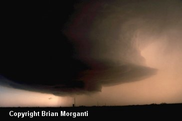
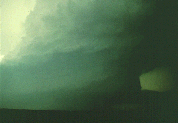
This
picture was initially a small supercell, looking west from about
5 miles, that packed a very intense rotating updraft. The rain curtains
extending beneath the storm base were rotating, and looked very
much like the rain areas we have seen under HP supercell bases.
Once again, note the vaulted appearance on the north (right) side
of the updraft. The storm was producing baseball size hail at this
time, and a low-pitched, subtle, and continuous roaring sound was
heard. Storm chasers have heard this a number of times, particularly
close to LP storms, and attribute it to hailfall. |
| |
High
precipitation (HP) Supercells like the one above
can occur in any part of the country. It was once
thought that HP cells only occurred in the Southeast,
but they have been documented in the great plains
as well. HP Supercells are easy to detect on radar.
Usually they have a large echo with evidence of
rotation within the storm. In some HP cells, the
mesocyclone is displaced to the southeast or east
side of the storm. This displacement, coupled with
the copious amounts of precipitation falling from
the storm, make HP cells difficulty to visually
identify. The heavy precipitation may obscure some
or all of the rain-free base area and obscure the
important cloud features that are found in this
area. However, HP cells will usually have a beavers
tail and a mid level cloud band. Thus, evidence
will exist to confirm that it is indeed a supercell. |
|
Photo
NOAA |
| |
|
| |
Tornadoes
that form within HP supercell storms are often difficult,
if not impossible to see. These are typically known
as rain wrapped and are some of the most dangerous
tornadoes to storm spotters and chasers. Often,
the only viewing area is from just outside the inflow
notch, which also will often put you within the
direct path of any tornado, so any attempts to get
in this area on an HP storm should only be done
with those with a great deal of experience in storm
spotting or chasing, and with plenty of road options
to get out of the area quickly. |
|
As
you can see here, even though we can discern visual
evidence of rotation within the storm by the midlevel
striations, we most certainly can not see if there
is a tornado in there or not! This is a very dangerous
storm to observers in the field. |
|
|
|
|
|
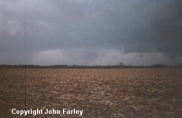
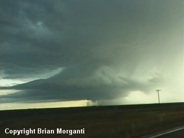
Low
Precipitation (LP) Supercells are most commonly found
on the High Plains near the dry line (sometimes they
are called "dryline storms"), but they have been documented
in the Upper Mid-West as well. LP cells are difficult
to detect on radar. The radar echos are usually small
and weak with low reflectivity values. LP storms are
fairly easy to identify visually. The typical LP supercell
has a translucent precipitation area. The main storm
tower is usually thin, bell shaped, and has corkscrew-type
striations on the sides of the tower. |
|
This
LP storm June 11, 1997 in Beaver County, OK produced
several small funnels. |
|
|
|
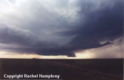
This
classic LP cell is producing a well defined wall cloud
as well as some strong inflow bands. |
|
|
| |
|
|
| |
|