| |
|
This
module compiled with information courtesy of the official NOAA Storm
Spotters Guide. This page contains sponsored links. |
| |
SECTION
ONE: |
 As in the other sections,
you can click on the glossary image wherever you see it, and the glossary
will open in another window. Just close that window when you are ready
to continue.
As in the other sections,
you can click on the glossary image wherever you see it, and the glossary
will open in another window. Just close that window when you are ready
to continue. |
|
THUNDERSTORM
DANGERS: |
| SAFETY TIPS: |
| When
spotting/chasing, travel in pairs whenever possible. When moving,
this will allow the driver to remain focused on the chore of driving
while the passenger keeps an eye on the sky and handles any communications.
When stopped, two sets of eyes are available for observation.
Keep
aware of the local environment at all times. When in the vicinity
of a thunderstorm, it would be preferable to keep at least a two
mile "buffer zone" between you and the storm. Frequently check the
sky overhead and behind to ensure no unexpected events (such as
a new tornado) are developing. Always, ALWAYS
have an escape route available, in case threatening weather approaches
or you get within the two mile "buffer zone". A good motto to remember
is to "keep your head on a swivel". Also remember, one
of the greatest dangers while mobile spotting or storm chasing is
DRIVING. Be aware that many people are not used to driving in bad
weather conditions. Also be VERY aware of hydroplaning conditions.
It doesn't take much water on the road to cause your vehicle to
hydroplane. For more information on hydroplaning, please read the
SAFETY GUIDE. |
| |
| LIGHTNING: |
| Let's
review the destructive and deadly thunderstorm elements
before introducing the thunderstorm spectrum. By definition,
all thunderstorms contain lightning. In most years it is
the thunderstorm's greatest killer. A possible contributing
reason for this is that lightning victims frequently are
struck before or after the occurrence of precipitation at
their location. Many people apparently feel safe from lightning
when not experiencing rain. This image of lightning was
taken while storm chasing, coming very close to the chase
vehicle. |
|
|
| |
| FLASH FLOODING: |
| |
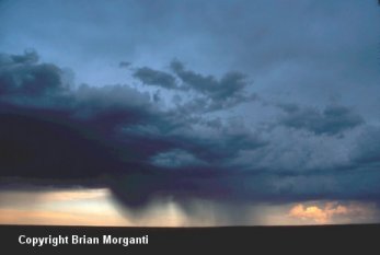
Cases
involving either slow-moving thunderstorms or series of storms
which move repeatedly across the same area (sometimes called
train-echo storms) frequently result in flash flooding. The
total number of flash flood deaths has exceeded tornado fatalities
during the last several decades. Two factors seem to be responsible
for this: public apathy regarding the flash flood threat and
increased urbanization. When concrete replaces soil, rain
water will run off rather than soak in. Flash flood producing
rainfall has made this type dramatic rescue attempt all too
familiar lately, especially in urban areas and popular mountain
camping spots. |
|
| HAIL: |
This
hailfall occurred near Clayton, New Mexico in 2003. At times
it reached the size of tennis balls! Hail causes more monetary
loss than any other type of thunderstorm-spawned severe weather.
Annually, the United States alone suffers about one billion
dollars crop damage from hail. Hail rarely kills people, but
these were hollow words in China in May, 1986 when 100 people
were killed, 9000 injured, and 35000 homes destroyed by an
intense hailstorm. Hail also killed a man in Ft. Worth, Texas
in 2000, when he was struck in the head trying to get to his
car to move it from a tornados path. |
|
|
| |
| THUNDERSTORM
OUTFLOW: |
| |
 |
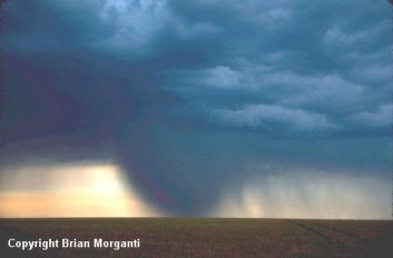
Thunderstorm
winds also cause widespread damage and occasional fatalities.
Thunderstorm "straight-line" winds originate from rain-cooled
air that descends with the accompanying precipitation. This
Kansas Derecho windstorm, approaching from the north, was
packing 80+ MPH winds (measured by chase vehicles at a maximum
of 106 mph behind the spectacular appearing gust front.
These same thunderstorms earlier produced several small
tornadoes, grapefruit size hail, and flash flood rainfall
before merging. |
|
|
|
OUTFLOW
DRIVEN DUST: |
After
the thunderstorm gustfront passes and before precipitation,
if any, arrives, blowing dust often is kicked up by thunderstorm
induced winds. The amount of dust depends on soil type, soil
moisture content, and wind intensity. Winds were estimated
to be about 50 MPH at this time along near Seminole, Texas.
Severe thunderstorm winds are especially dangerous to aviation
interests, particularly aircraft which are on final approach
or taking off in the presence of thunderstorm outflow winds.
|
|
| |
A
gust front marked by blowing dust near Altus, OK October 1,
1998. If you were in this position you could soon expect high
winds (and possibly blowing debris). |

Gust
front during a derecho event that began in Kansas May 27,
2001 and progressed south and east well into central Texas.
|
|
|
DOWNBURSTS: |
| |
| Damaging
thunderstorm winds have been termed downbursts by renowned severe
storm researcher Dr. Ted Fujita. Dr. Fujita further classifies these
events as macrobursts (greater than 2.5 miles in diameter) and microbursts
(less than 2.5 miles in diameter). Generally, a macroburst is on
the scale of the entire cold air outflow field of a thunderstorm
or a group of thunderstorms; whereas the microburst is a sub- thunderstorm
scale outflow feature. |
| MICROBURSTS
IMBEDDED IN MACROBURSTS: |
| 
above
photo by Moller |
| |
|
In
the top image we see a classic microburst occurring. This
is a southward view from within a mile of a microburst imbedded
within a macroburst. The transition line from ragged to smooth cloud texture, to the left and above the microburst, is where
the right to left-advancing macroburst meets cloud base. This
is the leading edge of the thunderstorm gustfront ahead of
a line of thunderstorms. Immediately behind the gustfront
and to the right side of the highway, the microburst has reached
ground and is in the process of "curling" over the highway.
Estimated wind speeds from moving dust parcels were 70 MPH.
In
the next picture we can see a broad macroburst area which
has kicked up dust out to the right of it for several miles,
even thought the "wet" part of it didn't reach out
that far.
We
will have more on the visual identification of microbursts
later. |
|
|
Beautiful
microburst in progress. |
| |
TORNADOS: |
Last but not least is the tornado. Again, a tornado is defined as a violently rotating column of air in contact with the ground and a pendant from a thunderstorm (whether or not a condensation funnel is visible to the ground). Winds during a tornado can range from 40mph to 318mph depending on the scale of the tornado...meaning the winds can go from picking up small objects like newspapers, to destroying whole houses. It's important to remember the damage a tornado can cause, & to keep safety in mind always. If a tornado is approaching your location, drive away from the tornado at a 90 degree angle IF you are in open country, IF the location and motion of the tornado are known, and IF you are familiar with the local road network. If you are in an urban area and escape is not possible for some reason, abandon your vehicle and get into a reinforced building. If one is not available, get into a culvert or ditch, or other low lying spot in the ground (that is not flooded). |

|
|
|
|
|
| |
|